Chicago, Illinois — Millions of Americans across the country are preparing for a prolonged stretch of unusual and potentially dangerous weather as a powerful Omega block weather pattern settles over the United States this week.
Meteorologists warn the pattern could trap regions under the same weather conditions for days, bringing everything from record heat and severe thunderstorms to heavy clouds and nonstop rain depending on location.
What Is an Omega Block Weather Pattern?
The weather setup gets its name because the jet stream pattern resembles the Greek letter Omega (Ω) high above the atmosphere.
According to the National Oceanic and Atmospheric Administration (NOAA), an Omega block forms when a large ridge of high pressure becomes trapped between two low-pressure systems on either side.
This creates what experts often describe as an “atmospheric traffic jam” because weather systems that normally move quickly from west to east suddenly slow down or become stuck over the same areas.
As a result, regions can experience prolonged periods of identical weather conditions, including:
- Extreme heat
- Severe storms
- Persistent rain
- Cloudy skies and fog
- Extended humidity
Forecasters say the full strength of the pattern should become clearer by midweek.
Northwest Faces Rainy and Damp Conditions
On the western side of the Omega block, a low-pressure system is expected to remain parked over the Pacific Northwest through the end of the work week.
This setup will likely bring repeated rounds of light to moderate rainfall across parts of the Northwest.
“These storms will be more of an annoyance than a major event,” the FOX Forecast Center said. “Expect repetitive rounds of light to moderate rain.”
Meteorologists also say southerly winds moving into the region could contribute to unusual warmth in some areas alongside the damp conditions.
While widespread severe weather is not expected in the Northwest, residents may experience several gloomy and wet days with little change in conditions.
Central U.S. Braces for Dangerous Heat
The middle section of the Omega block contains a powerful ridge of high pressure that is forecast to bring a major surge of heat into parts of the Central United States.
As the warm air becomes trapped beneath the ridge, skies are expected to stay mostly clear while temperatures climb dramatically.
Forecasters say some states could experience temperatures 15 to 25 degrees above average for this time of year.
The FOX Forecast Center explained that the heat will intensify as the ridge shifts toward the center of the country, causing warm air to sink and remain trapped over the region.
This could lead to several consecutive days of unusually hot weather and increased heat-related concerns.
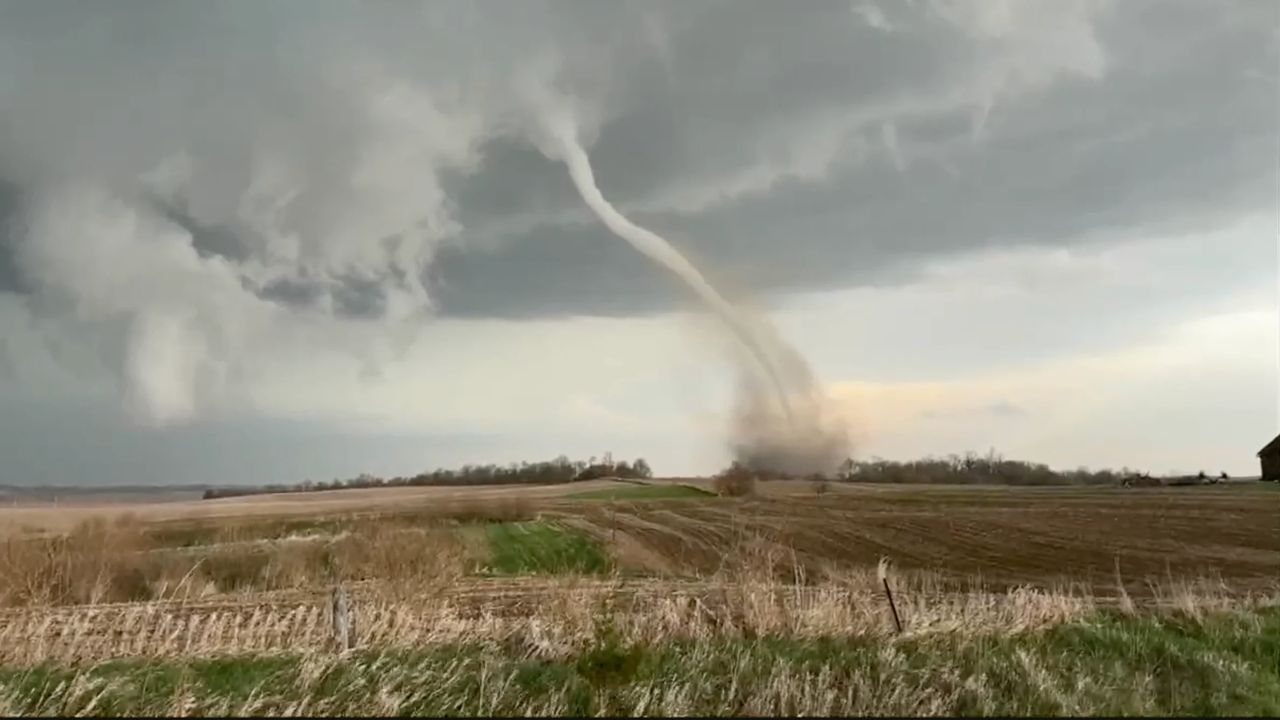
Severe Storm Threat for Midwest and East Coast
Meanwhile, the eastern side of the Omega block could bring a different kind of danger.
The Northeast and Mid-Atlantic regions are expected to face rounds of severe thunderstorms capable of producing:
- Damaging winds
- Large hail
- Heavy rainfall
- Possible localized flooding
Major cities including Chicago, Milwaukee, and Kansas City may experience strong storms as the system moves through.
Wildfire Emergency Near Miami Metro Sparks Smoke Warnings Across South Florida
Even after the worst severe weather passes, the stagnant nature of the Omega block is expected to keep dark clouds and scattered showers lingering across the Northeast into Friday.
Pattern Could Linger Through the Week
Forecasters say much of the United States will continue dealing with stagnant weather patterns for several days before conditions gradually begin to ease.
However, even after the strongest impacts fade, lingering effects from the Omega block may continue across several regions into the weekend.
Weather experts are encouraging residents nationwide to monitor forecasts closely as changing local conditions could still produce travel disruptions and hazardous weather.
Are you experiencing unusual weather in your area this week? Share your conditions and thoughts in the comments below.