Texas to Missouri: A multi-day severe weather outbreak is unfolding across the central United States, with the potential for strong tornadoes, destructive hail, damaging winds and flash flooding from Texas to Missouri and into parts of the Midwest.
Forecasters warn that Thursday into Friday could bring the most significant threat, with some tornadoes possibly reaching EF2 intensity or stronger. The severe pattern is expected to persist into the weekend and early next week.
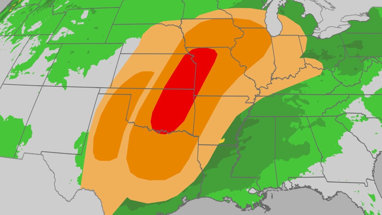
According to the NOAA Storm Prediction Center, multiple rounds of thunderstorms will impact the Plains and Midwest as a stalled weather pattern fuels repeated storm development.
Severe Weather Timeline and Areas at Risk
Wednesday: Hail, Damaging Winds and Isolated Tornadoes
Severe thunderstorms are expected from parts of northern Texas into the mid-Mississippi and lower Ohio valleys, primarily during the afternoon and evening.
Primary threats include:
- Large hail up to 2 inches in diameter
- Wind gusts up to 70 mph
- A few possible tornadoes
Cities potentially impacted:
- Dallas, Texas
- Fort Smith, Arkansas
- Springfield, Missouri
Thursday: Strong Tornado Risk Along the Dryline
Thursday’s severe threat is expected to intensify, especially along a dryline stretching across western Texas into western and central Oklahoma and southwestern Kansas.
Meteorologists warn that:
- Several tornadoes could be strong (EF2 or higher)
- The Oklahoma City metro area may be at risk by evening
- Hail larger than golf balls is possible
- Damaging straight-line winds could accompany supercells
Cities at risk Thursday:
- Lubbock, Texas
- Amarillo, Texas
- Wichita Falls, Texas
- Oklahoma City, Oklahoma
- Omaha, Nebraska
Friday: Widespread Outbreak Possible
Friday may bring the most widespread severe outbreak of this event.
The National Oceanic and Atmospheric Administration has issued a Level 3 severe weather outlook for Day 3, indicating enhanced risk across parts of northern Texas into western Missouri.
Forecasters highlight:
- Numerous supercell thunderstorms
- Strong tornado potential (EF2 or greater)
- Hail exceeding golf ball size
- Destructive thunderstorm winds
Severe storms with hail may extend as far north as southern Minnesota and the southern Great Lakes, including Chicago.
Cities in the higher risk zone:
- Austin, Texas
- Dallas, Texas
- Oklahoma City, Oklahoma
- Tulsa, Oklahoma
- Kansas City, Missouri
- Des Moines, Iowa
- Chicago, Illinois
Weekend and Early Next Week: Continued Storm Threat
The severe pattern does not end Friday.
- Saturday: Strong to severe storms possible from the Ohio Valley into eastern and central Texas
- Sunday: Additional severe storms possible in parts of the South
- Early next week: Another strong cold front may trigger renewed severe storms across the Plains
The Storm Prediction Center has already flagged Tuesday for additional severe weather risk in some of the same areas impacted this week.
Heavy Rain and Flash Flooding Concerns
Along with tornadoes and hail, heavy rainfall is expected.
Some areas from the Southern Plains into the Mississippi and Ohio valleys could receive more than 3 inches of rain where repeated storms develop.
Flash flooding is especially possible in:
- The Ozark Mountains
- The Ouachita Mountains
- Eastern Oklahoma
- Western Arkansas
- Southwest Missouri
Localized flooding could occur rapidly in low-lying or mountainous terrain.
Why This Pattern Is Happening: La Niña Influence
Much of the South has been dealing with drought conditions, and this outbreak may bring much-needed rainfall.
Data from the US Drought Monitor shows ongoing drought across large portions of the South.
The underlying driver of this winter’s weather has been La Niña, which shifts global atmospheric patterns.
During a La Niña:
- Trade winds strengthen across the equatorial Pacific
- Warmer water shifts westward
- Cooler water rises in the eastern Pacific
- The jet stream is pushed farther north
This typically results in:
- Warmer and drier conditions across the southern U.S.
- More frequent storm systems tracking across the northern states
As La Niña begins to fade, shifting jet stream patterns can contribute to volatile severe weather setups during March.
How to Prepare for Severe Weather
With tornadoes, large hail and damaging winds possible, residents across the central U.S. should:
- Have multiple ways to receive weather alerts, including overnight notifications
- Know the safest shelter location in their home (interior room, lowest floor, away from windows)
- Monitor updates from local weather authorities
- Act immediately when a warning is issued
Severe weather season typically ramps up in March, and this week’s pattern reflects classic ingredients for a significant early-season outbreak.
Final Outlook
From Texas through Missouri and into parts of the Midwest, the next several days could bring a prolonged stretch of dangerous weather conditions. Strong tornadoes, damaging winds, destructive hail and flash flooding are all possible through Friday, with additional threats extending into next week.
Residents are urged to stay alert and prepared as this evolving severe weather event unfolds across the nation’s midsection.