Wichita, Kansas — A potentially dangerous stretch of severe weather is developing across the Great Plains and Midwest, with forecasters warning that strong winds, large hail, and widespread thunderstorms could impact millions through the weekend.
Meteorologists say the changing weather pattern comes after days of intense heat across the central United States, as atmospheric conditions now become more favorable for storm development.
Severe Weather Setup Taking Shape
The storm threat is increasing as the long-lasting Omega block weather pattern begins to weaken. This pattern previously trapped heat across the central U.S., but experts say the atmosphere is now shifting.
As the high-pressure system weakens and flattens, multiple storm systems are expected to move into the Plains, creating conditions supportive of severe thunderstorm formation.
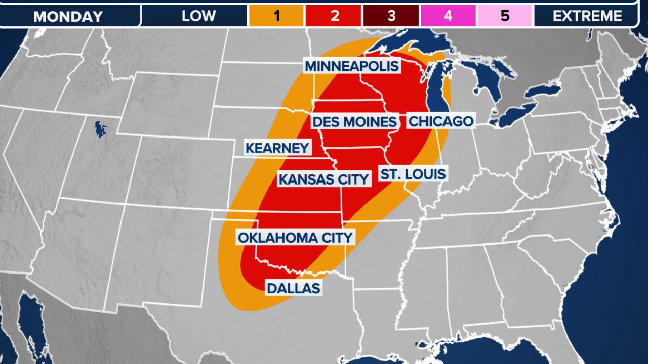
According to the National Oceanic and Atmospheric Administration (NOAA), parts of central Kansas, including Wichita, are currently under a Level 2 out of 5 risk for severe thunderstorms.
Forecasters believe a mid-level wave moving eastward combined with a developing dryline could spark intense storms across the region.
Large Hail and Damaging Winds Possible
Weather experts say nearly all the atmospheric ingredients needed for severe storm development will be in place over the coming days.
If thunderstorms manage to fully develop, they could produce:
- Damaging wind gusts
- Large hail up to 2 inches in diameter
- Heavy rainfall
- Frequent lightning
However, meteorologists are also watching a possible limiting factor known as a “stout cap.”
A stout cap refers to a layer of warm air several thousand feet above the ground that can temporarily suppress thunderstorm development.
If this atmospheric cap weakens or breaks, severe storms could rapidly intensify.
Storm Threat Expected to Continue Into Saturday
The active weather pattern is forecast to continue through Saturday as a stronger low-pressure system develops across the northern Plains.
This system is expected to pull additional moisture into the atmosphere, further increasing storm potential across parts of the Midwest and North-Central United States.
Forecasters warn that moisture-rich air combined with unstable atmospheric conditions may support stronger and more widespread thunderstorms heading into the weekend.
Upper-Level Trough Could Increase Storm Activity
Beginning Sunday, the broader weather pattern is expected to evolve even further as an upper-level trough settles over the western United States.
This setup is forecast to generate strong southwesterly winds over the Great Plains, helping transport warm, humid air northward.
Meteorologists expect a significant increase in low-level moisture, with surface dew points reaching the mid to upper 60s across much of the North-Central U.S.
This added moisture, combined with upper-level energy, could create an even more favorable environment for storm development.
Forecasters Watching for Stronger Storms Next Week
Experts say several subtle atmospheric disturbances, known as shortwave troughs, may move through the region and trigger repeated rounds of thunderstorms during the afternoon and evening hours.
“A series of subtle shortwave troughs moving through this environment will likely trigger scattered to numerous thunderstorms during the afternoon and evening hours,” the FOX Forecast Center said.
Meteorologists also noted that extreme moisture combined with wind shear could allow some storms to strengthen further.
Kansas Dad Allegedly Left Kids in 130-Degree Car for Hours While Working—3-Year-Old Daughter Dies
As the severe weather pattern continues evolving, forecasters expect additional rounds of wet and stormy weather to impact parts of the Plains and Midwest early next week.
Residents in affected areas are being urged to stay alert for watches and warnings as conditions may change quickly.
Are severe storms expected in your area this weekend? Share your thoughts and weather updates in the comments below.