Norman, Oklahoma — Millions of Americans across multiple regions of the country are being warned to prepare for potentially severe weather as forecasters track thunderstorms capable of producing damaging winds, hail and isolated power outages from the Mid-Atlantic to Texas.
The National Weather Service’s Storm Prediction Center (SPC) says scattered severe thunderstorms could develop Wednesday across parts of the Mid-Atlantic, western Great Lakes and West Texas, continuing an already active stretch of dangerous weather.
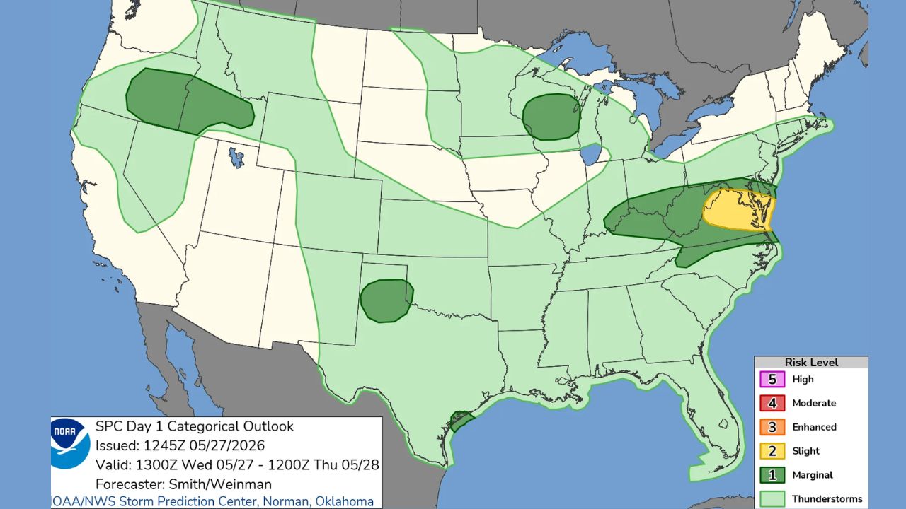
Mid-Atlantic Faces Threat of Damaging Winds
Forecasters say some of the strongest storms could develop from portions of the Ohio Valley into the central Appalachians and Mid-Atlantic region during the afternoon and evening hours.
According to the SPC:
“Scattered severe thunderstorms are possible across parts of the Mid-Atlantic states this afternoon into the early evening.”
Meteorologists warn that the biggest concern with these storms will be powerful wind gusts capable of causing damage.
“Strong to severe gusts (50-65 mph) capable of wind damage will be the primary hazard with the stronger thunderstorms.”
Officials say these storms could down tree limbs, damage weaker structures and trigger isolated power outages across affected areas.
Some storms may also produce marginally severe hail, with hailstones potentially reaching around one inch in diameter or larger.
Texas and Oklahoma Could See Evening Storm Development
The SPC also highlighted parts of West Texas, the southern Texas Panhandle and far western Oklahoma as areas at risk for isolated severe thunderstorms later Wednesday.
Forecasters say a combination of daytime heating and increasing moisture could help fuel storm development by late afternoon and evening.
The broader Texas region has already experienced repeated rounds of unsettled weather in recent days, including overnight thunderstorms near the Gulf Coast.
Meteorologists describe the current setup as an “active storm pattern,” meaning multiple storm systems are expected to continue affecting similar areas over several days.
Great Lakes Region Monitoring Hail and Wind Threats
In the western Great Lakes region, including parts of Wisconsin, forecasters are also tracking the possibility of isolated severe storms.
Weather experts say thunderstorms in that region could produce large hail and damaging winds as a weather disturbance moves through the area.
Although storms may remain scattered, officials caution that even isolated severe thunderstorms can quickly become dangerous for travelers and outdoor activities.
Northwest Could Face Severe Weather Thursday
The severe weather threat is expected to shift farther west by Thursday, with the SPC placing portions of Oregon, Washington, Idaho and western Montana under a Marginal Risk for severe thunderstorms.
A Marginal Risk represents Level 1 out of 5 on the SPC’s severe weather scale, indicating isolated severe storms are possible but generally limited in intensity and coverage.
Gloomy Weather Isn’t Done Yet: More Rain and Even Snow Possible Across New England This Weekend
Forecasters say an upper-level low pressure system moving from California into Nevada will likely help trigger scattered storms across parts of the Pacific Northwest and northern Rockies.
These systems can increase atmospheric instability and help thunderstorms strengthen rapidly.
Residents Urged to Stay Weather Aware
Meteorologists are encouraging residents in impacted areas to closely monitor local forecasts and weather alerts throughout the week.
Strong thunderstorms can develop quickly, especially during late afternoon and evening hours, bringing sudden damaging winds, dangerous lightning and hail.
Officials also remind drivers to use caution during severe weather and avoid flooded roadways or areas with downed power lines.
How is the weather looking in your area this week? Share your thoughts and local conditions in the comments below.