NEW YORK, NY — If you’ve enjoyed the recent stretch of summerlike warmth across the Eastern United States, experts say you should enjoy it while it lasts. A major shift in atmospheric patterns is set to deliver a “painful reality check,” as record-breaking heat is replaced by a late-season cold shock that could see temperatures plummet by as much as 60 degrees in some areas.
For tens of millions across the Midwest and the East, the current week has felt more like July than mid-April. However, meteorologists warn that the clock is ticking on this early summer preview.
Records Shattered Across the Mid-Atlantic
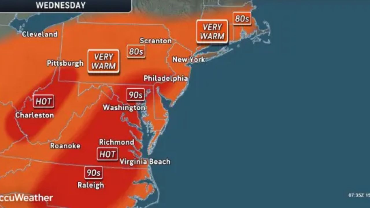
On Wednesday, several cities saw daily record highs fall as a heatwave gripped the region. Philadelphia and Baltimore both soared to 91°F, while Washington, D.C., reached 90°F. This marks the earliest Philadelphia has hit the 90-degree mark since 2002.
AccuWeather Senior Meteorologist Courtney Travis noted that the heat might not be done yet. In the nation’s capital, temperatures could approach the all-time April record of 95°F before the cool-off begins. Farther south, cities like Charlotte and Atlanta are also on track to challenge century-old temperature records through Saturday.
The “Cold Shock”: A 60-Degree Temperature Drop
While the South holds onto the heat, a powerful storm system moving through the Intermountain West is bringing a dramatic change. This system is expected to drag a massive pocket of Arctic-chilled air eastward this weekend.
The transition won’t be subtle. Many locations will experience:
- Daytime Highs: Summerlike warmth on Friday and Saturday.
- Nighttime Lows: Plummeting into the 20s and 30s by Sunday and Monday.
- Extreme Swings: A potential 50- to 60-degree drop in temperature within a 48-hour window.
By Monday morning, freezing conditions are forecast for Madison, WI; Lansing, MI; and Binghamton, NY. By Tuesday, the freeze will expand into Cleveland, OH; Allentown, PA; and Worcester, MA, even reaching coastal pockets like Long Island and southern New Jersey.
Threat to Agriculture and Gardens
This “weather whiplash” poses a significant threat to local agriculture and home gardeners. Because of the unusually warm start to April—running 2 to 8 degrees above historical averages—many trees, vines, and bushes have already begun to bud or blossom.
“Multiple days of unusually warm conditions… will tend to accelerate budding and blossoming earlier than usual,” explained AccuWeather Lead Long-Range Meteorologist Paul Pastelok.
What you need to do:
- Protect Plants: If you have already started your spring planting or have hanging baskets outdoors, bring them inside or cover them with frost blankets.
- Fruit Production Risk: Farmers are concerned that damaged buds and blossoms from this freeze could negatively impact fruit production later this year.
- Pet Safety: Ensure outdoor pets have adequate warmth as nighttime lows dip far below what they have experienced recently.
A Silver Lining for the Southeast?
While the North prepares for the cold, the Southeast may see some relief of a different kind. The transition from extreme heat to cooler air is expected to bring much-needed rainfall. This region has been battling drought conditions and an increased risk of wildfires, so any precipitation will be a welcome change for local fire departments and farmers.
Experts suggest that while temperatures will rebound after a couple of days, this may not be the last cold snap. Atmospheric patterns in the North Pacific suggest that additional cool periods could return later in April and even into May.
Is your garden ready for the freeze? How are you preparing for this 60-degree temperature swing? Share your tips and local weather sightings in the comments below!