Southern U.S. Heat Wave: Meteorological spring officially began on March 1, but for millions across the South, the weather will feel much closer to early summer than the start of a new season.
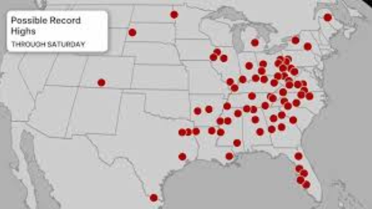
Forecasters say dozens of daily high-temperature records could fall this week from the Plains to the mid-Atlantic — and even into parts of the Great Lakes — as an unseasonably strong warm air mass spreads eastward.
Record Heat Expands Across the South and East
The warmup will intensify during the latter half of the week, bringing widespread above-average temperatures to:
- The Southern Plains
- The Southeast
- The Mid-Atlantic
- The Great Lakes
- Portions of the Northern Plains
Friday is expected to be the peak day for record-breaking heat in many locations.
High temperatures could run 25 to 30 degrees above average for early March, a significant departure from seasonal norms.
Cities That Could See Record Highs
On Friday, daily record highs may fall from:
- Houston, Texas
- Tampa, Florida
- Atlanta, Georgia
- Memphis, Tennessee
- Charlotte, North Carolina
- Raleigh, North Carolina
- Cincinnati, Ohio
- Indianapolis, Indiana
- Washington, D.C.
The warm air mass will be expansive enough to push unusually mild conditions deep into the Ohio Valley and Mid-Atlantic.
By Saturday, even cities such as Pittsburgh could see temperatures climb into the 70s — well above typical early March averages.
Northeast Also Feeling Spring-Like Temperatures
The warmth won’t stop in the South.
Parts of the Northeast, including:
- Southern New England
- The New York City tri-state area
- Portions of upstate New York
could see temperatures reach the 60s by the weekend.
This shift will feel especially dramatic in areas that recently endured significant snowfall from Winter Storm Hernando less than two weeks ago. The contrast between recent snow accumulation and near-spring warmth highlights the volatility typical of early March weather patterns.
Why Is It So Warm?
This surge of warmth is being driven by:
- A strong ridge of high pressure across the eastern U.S.
- Southerly winds pulling warm Gulf air northward
- A jet stream pattern allowing heat to build across central and eastern states
Such patterns are not uncommon during seasonal transitions but can produce sharp swings in temperature.
How Long Will the Warm Weather Last?
Despite the summer-like feel, the warm spell is not expected to linger.
A significant pattern change is forecast to develop beginning Tuesday:
- Colder air will push southward from Canada into the Rockies and Plains.
- The chill will then expand eastward into the South and East later next week.
- Temperatures are expected to return closer to — or below — seasonal averages.
This type of back-and-forth pattern is typical during meteorological spring, when strong temperature contrasts frequently develop across North America.
What to Expect Next Week
As colder air arrives:
- High temperatures may drop sharply in the Plains and Rockies first.
- The South and East could see noticeable cooling by mid-to-late next week.
- Some areas may experience brisk winds as the front moves through.
Residents are encouraged to enjoy the brief stretch of warm weather while remaining prepared for the return of cooler conditions.
Conclusion
Millions across the South, Southeast, and Mid-Atlantic are poised to experience record-challenging heat this week, with temperatures soaring 25 to 30 degrees above average in some areas.
While the warmth will provide a preview of spring — and even summer — it is expected to be short-lived. A strong push of Canadian air next week will bring temperatures back down, reminding everyone that March weather can change quickly.
For now, it’s a rare early-season heat wave offering a temporary break from winter before cooler air returns.