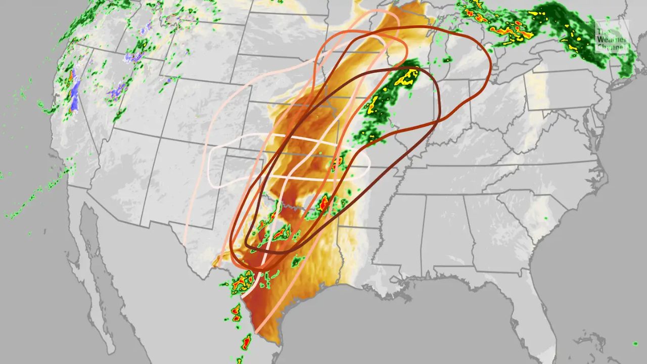
CHICAGO, IL — Millions of residents across the central United States are being urged to stay weather-aware this week as a relentless pattern of severe thunderstorms takes aim at the region. AccuWeather meteorologists are warning of a multi-day threat that includes isolated tornadoes, destructive hail, and “significant” flooding risks.
While the incoming rain may provide much-needed relief to drought-stricken areas in the Plains and Mississippi Valley, other regions are bracing for disaster. In the northern Midwest, repeated downpours could worsen ongoing flooding caused by rapid snowmelt and already dangerously high river levels.
Monday: Dual Threat Zones
The week kicks off with two primary areas of concern. The first risk zone stretches across the Midwest, covering South Dakota, Iowa, northern Illinois, and Michigan, with a heightened concentration of danger expected in Wisconsin and southern Minnesota.
Farther south, a second storm cell is focusing on central Oklahoma and Texas. According to AccuWeather Meteorologist Breanna Grill, residents in both regions should prepare for large hail, damaging wind gusts, and the potential for isolated tornadoes and flash flooding.
Tuesday: The Most Dangerous Day of the Week
Weather experts are circling Tuesday as the most significant day for severe weather. A powerful storm system—the same one that recently brought snow and rain to California—is moving into the Plains, creating a massive danger zone.
A “large swath” of the country, stretching all the way from Texas to Michigan and northern Pennsylvania, will be at risk. This system carries the threat of destructive hail and damaging wind gusts reaching up to 85 mph (AccuWeather Local StormMax™). Because this day presents the highest risk for tornadoes, officials are urging individuals to have multiple ways to receive emergency alerts on their phones.
Wednesday & Friday: The Threat Persists
By Wednesday, the storm track shifts slightly eastward. However, many areas that were hit earlier in the week will remain in the crosshairs. Cities from northern Texas up to Michigan and northern Ohio could see a continuation of hail and localized wind damage.
After a brief potential lull, the risk returns on Friday as a new storm dives out of the Northwest. This final round of the week is expected to impact a corridor from Texas through the Dakotas and into western Wisconsin, once again bringing the threat of tornadoes and severe gusts.
Flooding Concerns Rise
Beyond the immediate danger of wind and hail, the cumulative effect of these “repeated rounds” of storms is raising alarms for flash flooding. Ground that is already saturated from snowmelt in the North cannot absorb the predicted heavy downpours, leading to a high probability of road closures and property damage near river basins.
Safety Checklist for Local Residents:
- Charge Devices: Keep your phones and power banks charged in case of outages.
- Secure Outdoors: Bring in patio furniture or loose items that could become projectiles in 85 mph winds.
- Monitor Water Levels: If you live near a creek or river, stay alert for rising water levels.
- Seek Shelter: Identify the lowest, most central room in your home as your “safe spot” during tornado warnings.
Is your community prepared for this week’s storms? Have you already seen rising water levels in your area? Share your local weather updates and photos in the comments below to help your neighbors stay informed.