A powerful storm system is set to impact the Southern Plains this week, bringing the potential for several days of heavy rain and severe thunderstorms. Forecasters warn that damaging winds, large hail, and even isolated tornadoes are possible as the system strengthens.
While uncertainty remains about which communities will experience the worst impacts, confidence is growing that the region will face a significant stretch of active weather beginning midweek.
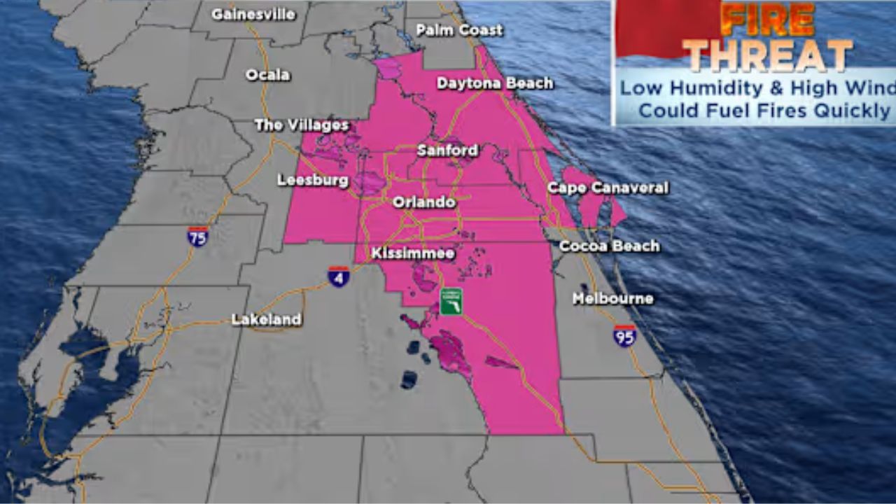
Ironically, many of these areas desperately need rainfall due to ongoing drought conditions.
When Will the Storms Arrive?
Light rainfall early in the week will shift toward the Northeast and is not connected to the more serious threat.
The primary concern begins Tuesday night, when rich Gulf moisture surges northward and collides with cooler, dry air still in place across the Northern United States. This type of atmospheric setup is a classic trigger for severe weather across the Plains.
Tuesday Night: Threat Begins
Storms are expected to develop across parts of Texas and Arkansas late Tuesday as the system becomes more organized. Severe thunderstorms are possible along the southern edge of the developing system.
Wednesday: Highest Risk Window
Wednesday currently appears to be the most concerning day for severe weather.
The Storm Prediction Center has highlighted portions of the Southern Plains — particularly from Texas into Arkansas — for potential severe storms.
Primary threats include:
- Damaging straight-line winds
- Large hail
- Isolated tornadoes
When forecasters begin flagging severe weather potential nearly a week in advance, it typically signals a setup worth monitoring closely.
Wednesday Night Through Thursday: Threat Continues
The severe weather risk may persist into Wednesday night and Thursday.
Areas from Texas northward into southern Nebraska, and east toward Missouri and Arkansas, could see additional strong to severe storms.
As the system evolves, forecast details will become clearer regarding exact timing and impact zones.
How Much Rain Could Fall?
Heavy rainfall is expected with this system, with some locations receiving multiple days of downpours.
Forecast guidance suggests:
- 1 to 3 inches of rain across parts of the Southern Plains
- Isolated higher totals where storms repeatedly move over the same areas
While the rain will help ease drought conditions in some places, excessive rainfall could also lead to localized flooding concerns.
Why Has It Been So Dry?
Much of the Southern U.S. has experienced persistent drought this winter, largely due to La Niña conditions in the Pacific Ocean.
During La Niña:
- Stronger trade winds push warm water toward the western Pacific
- Cooler water rises in the eastern Pacific
- The jet stream shifts farther north
This pattern often leaves the southern United States warmer and drier, while sending most storm systems and cooler air into northern states.
Now, as seasonal transitions occur, that dry pattern is breaking down — opening the door for more active storm systems.