Minneapolis, Minnesota — After weeks of unusually chilly spring weather across parts of the Northern United States, a dramatic temperature swing is about to bring summer-like heat to the Upper Midwest and Northern Tier.
Forecasters say the rapid warm-up will push temperatures far above average across several states, creating a sharp contrast from the cooler conditions that dominated much of May.
Cooler-Than-Average Spring Suddenly Ends
While much of the western and southeastern United States experienced an exceptionally warm spring, regions across the Northern Tier and Upper Midwest remained noticeably cooler than average.
Cities including Minneapolis, Green Bay and Detroit recorded temperatures several degrees below seasonal norms throughout much of May.
According to the FOX Forecast Center, the area experienced some of the largest temperature anomalies of the spring season, with cooler air lingering far longer than expected.
That pattern is now shifting quickly.
Meteorologists say temperatures are expected to climb dramatically through Tuesday and Wednesday as warmer air spreads across the Northern Plains, Upper Midwest and Great Lakes.
Temperatures Could Climb 20 Degrees Above Normal
Forecast models show daytime highs rising between 10 and 20 degrees above average across multiple states this week.
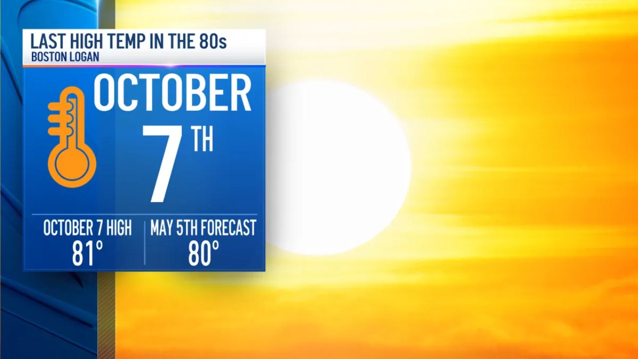
The biggest jump may occur in Minneapolis, where temperatures could approach 90 degrees for the first time since October 2025.
If the city reaches that mark, it would become Minneapolis’ warmest day in approximately 231 days.
The sudden change from chilly spring weather to intense warmth is expected to catch many residents off guard, especially after weeks of cooler temperatures and below-average conditions.
Some locations across the Northern Plains may even challenge daily temperature records during the early part of the week.
Rapid Weather Shift Raises Concerns
According to forecasters, the biggest story may not necessarily be record heat itself, but rather the speed at which temperatures are changing.
The transition from below-average spring conditions to near-summer heat in just a matter of days can place stress on people, pets and infrastructure that may not yet be fully prepared for hot weather.
Weather experts are also warning residents not to underestimate cold water dangers despite the warmer air temperatures.
“The warmer air is also a good reminder that, despite the heat, water temperatures remain chilly, generally in the middle to lower 50s,” the forecasters said.
Cold water temperatures can still pose serious risks for swimmers, boaters and anyone participating in outdoor water activities, even when air temperatures feel hot.
Heat Expected to Continue Into Early June
Long-range forecasts suggest the warming trend may continue beyond this week.
According to outlooks from the Climate Prediction Center, much of the Northern Tier is expected to remain above average through early June after the unusually cool start to May.
That means many cities across the region could continue seeing warmer-than-normal conditions heading into the first weeks of summer.
The changing weather pattern is expected to bring a major shift in daily routines for millions of people who have spent much of spring dealing with chilly mornings, jackets and below-average temperatures.
As the heat settles in, residents are being encouraged to stay hydrated, limit strenuous outdoor activity during peak afternoon hours and remain cautious around cold lakes and rivers.
What do you think about this sudden shift from spring chill to summer-like heat? Share your thoughts in the comments below.