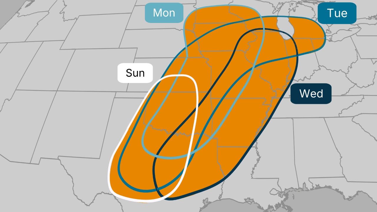
ROCHESTER, MN — Residents across Southern Minnesota are being urged to keep a close eye on the sky this coming Monday. While the weekend starts with a mix of humidity and scattered showers, meteorologists are tracking a more “concerning” setup that could trigger a significant severe weather outbreak by Monday evening.
Forecasters warn that if the right atmospheric “ingredients” align, Mother Nature could bake up a dangerous batch of storms capable of producing tornadoes, large hail, and damaging wind gusts.
The Setup: A Stalled Front and Rising Humidity
According to meteorologists, the primary concern revolves around a frontal boundary that is expected to stall over Southern Minnesota on Monday. This boundary acts as a staging ground for storm development.
The conditions on the ground will certainly feel like storm weather:
- Temperatures: Expected to climb into the 70s and low 80s.
- Dew Points: Surging to 60+, creating a “juicy” atmosphere for storms to tap into.
- The “CAP” Factor: A layer of warm air aloft (the CAP) might keep things quiet during the day, but experts warn that once this “lid” breaks in the evening, the result could be explosive.
Monday Evening: The “Danger Zone”
Meteorologist Sven Sundgaard notes that the timing of these storms is critical. “The earlier storms can develop, the more severe they could potentially be,” Sundgaard explained.
Current computer models, including the European and RRFS models, are starting to show a consistent picture:
- Evening Eruption: A cluster of intense supercells could erupt near the Minnesota-Iowa border on Monday evening.
- Low-Level Jet: Winds at 4,000 feet are expected to accelerate after dark, providing the shear necessary for rotating storms.
- Multiple Threats: If the cap breaks, all severe weather hazards—including isolated tornadoes—remain on the table.
Severe Weather Awareness Week
The timing of this threat is particularly notable as Minnesota begins its Severe Weather Awareness Week (April 13-17). Local officials remind residents that this is the perfect time to review safety plans and ensure weather radios are functional.
The National Severe Storms Laboratory’s machine-learning models are already flagging Monday as a day with high-end potential, though they emphasize that it is “conditional” on the storms actually breaking through the warm air cap.
What You Should Do Now
As we are still a few days out, the exact track of the warm front could shift. Southern Minnesota residents from Worthington to Rochester and Albert Lea should:
- Have multiple ways to receive weather alerts (phone apps, sirens, and NOAA radios).
- Clear loose outdoor furniture that could become a projectile in high winds.
- Stay tuned for updates as the short-term models get a better grasp on the storm’s timing.
What’s your plan, Southern MN? Do you have a designated storm shelter ready, or are you still prepping for the first big storms of the season? Share your weather photos and local updates in the comments below!