Dallas, Texas — A volatile weather pattern is taking hold across the central United States, with forecasters warning that a major severe weather outbreak could unfold Friday from Texas to Iowa, bringing the potential for strong tornadoes, giant hail, damaging winds, and flooding rain.
Meteorologists say the active pattern could last several days, with repeated rounds of thunderstorms expected across the Plains and Midwest through the middle of next week.
The escalating storm threat arrives as March begins with atmospheric conditions favorable for severe weather development across the nation’s midsection.
Strong Tornado Risk Expands Across the Plains
Forecasters say the most dangerous storms could develop Friday afternoon and evening as warm, moisture-rich air from the Gulf of Mexico collides with a powerful storm system moving across the Plains.
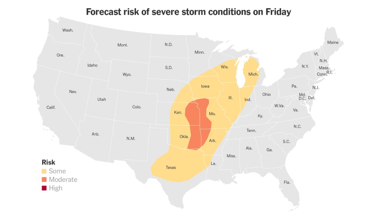
According to the NOAA Storm Prediction Center, parts of the region are under a Level 3 out of 5 severe weather risk, indicating the potential for widespread severe storms.
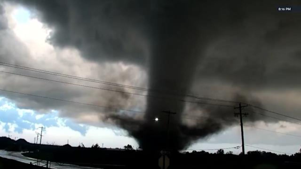
Meteorologists warn that supercell thunderstorms capable of producing strong tornadoes — including EF2 intensity or stronger — may develop from northern Texas into parts of Nebraska and Iowa.
In addition to tornadoes, forecasters say storms could produce damaging wind gusts and extremely large hail, with some hailstones potentially reaching baseball size or larger.
Storms Already Producing Tornado Reports
The severe weather pattern is already producing dangerous conditions across parts of the Plains.
Several tornadoes were reported Thursday evening in western and northwestern Oklahoma, including areas near Cleo Springs and Wakita.
Those early storms may signal the start of a broader outbreak expected to intensify heading into Friday.
Major Cities in Storm Corridor
The corridor of severe weather could stretch from the Southern Plains into the Midwest, putting millions of people in the potential path of dangerous storms.
Cities that could see severe weather include:
• Austin and Dallas, Texas
• Oklahoma City and Tulsa, Oklahoma
• Kansas City, Missouri
• Omaha, Nebraska
• Des Moines, Iowa
• Chicago and Madison
• St. Louis, Missouri
Storms may begin forming early Friday across the Central Plains before expanding into a larger outbreak during the afternoon and evening.
Some severe storms with hail could even extend into southern Minnesota and parts of the Great Lakes region.
Storm Threat Could Continue Through Next Week
Forecasters say the severe weather risk will not end after Friday.
Additional storms could develop Saturday across parts of the Ohio Valley, Appalachians, and eastern Texas.
By Sunday, a stalled frontal boundary may trigger isolated strong storms across parts of the South.
Another round of potentially severe weather could arrive early next week, when a strong cold front pushes eastward across the central and eastern United States.
The Storm Prediction Center has already signaled a renewed severe storm risk Tuesday, including some of the same areas affected by the current outbreak.
Flash Flooding Concerns Increasing
Along with tornadoes and damaging winds, heavy rainfall could lead to localized flash flooding across parts of the Plains and Ohio Valley.
Flooding has already occurred in several areas earlier this week.
In the Dallas area, emergency crews conducted water rescues on flooded roads, while parts of Millville, Ohio experienced several inches of water impacting homes and businesses.
Some cities have already set rainfall records during the storm pattern.
• Dallas recorded 1.55 inches of rain Tuesday, breaking a record set in 1937.
• St. Louis recorded 1.74 inches, surpassing a record from 1935.
Forecasters warn that some locations from the Southern Plains into the Mississippi and Ohio valleys could receive three inches or more of additional rainfall in the coming days.
Areas most vulnerable to flooding include eastern Texas, eastern Oklahoma, Arkansas, northern Louisiana, and parts of the Ohio Valley.
Rainfall Could Help Ease Drought Conditions
While the storms bring serious hazards, the rainfall may provide relief to areas experiencing drought conditions across the South.
Meteorologists say the dry conditions are largely tied to the ongoing La Niña pattern.
During La Niña winters, stronger trade winds shift warm ocean water westward across the Pacific, causing cooler water to rise in the eastern Pacific.
This shift often pushes the jet stream farther north, leaving much of the southern United States warmer and drier than normal.
As a result, many areas across the Southern Plains and South have seen reduced rainfall during the winter months.
The upcoming storms may help restore some of that missing moisture, although the severe weather risks remain significant.
Read Also: Tornadoes, Giant Hail and 75 MPH Winds Threaten Missouri Valley Friday Night
Preparation Urged as Storms Approach
With the potential for tornadoes and severe storms, emergency officials urge residents across the Plains and Midwest to prepare ahead of time.
Safety experts recommend:
• Enabling emergency weather alerts on mobile devices
• Having multiple ways to receive warnings overnight
• Identifying the safest place in the home to shelter during a tornado
• Avoiding travel during severe storms when possible
Because some storms could occur overnight, meteorologists stress the importance of receiving alerts even while sleeping.
Are you located in one of the states expecting severe storms this week? Share what conditions look like in your area and how your community is preparing in the comments below.