CHICAGO, IL — The Midwest and Plains are bracing for what meteorologists are calling a “multi-day siege” of violent weather. After a week that has already seen over 630 reports of severe storms and 40 suspected tornadoes, experts warn that Friday may bring the most serious threat yet to states already reeling from repeated pounding.
A dangerous combination of atmospheric ingredients is expected to trigger widespread thunderstorms, strong tornadoes, and flash flooding across a massive swath of the country, stretching from the Southern Plains to the upper Mississippi Valley.
Friday’s High-Risk Forecast: Where the Danger is Greatest
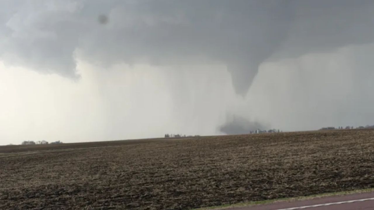
The National Weather Service has flagged eastern Iowa, northern Illinois, and southern Wisconsin as the primary zones for “strong tornadoes” during the late afternoon and early evening hours.
As the sun sets, the threat will transition into a massive squall line capable of producing:
- Destructive Wind Gusts: Especially in northwestern Missouri and eastern Kansas.
- Embedded Tornadoes: Quick-forming twisters hidden within rain clouds.
- Large Hail: Potential for stones the size of baseballs or larger.
Residents in cities like Chicago, Des Moines, and Milwaukee are urged to have multiple ways to receive weather alerts, as this activity is expected to continue well into the night when tornadoes are hardest to spot.
Historic Flooding Paralyzes Michigan and Wisconsin
While the wind and tornadoes capture headlines, a “silent killer” is emerging in the Great Lakes region. The combination of heavy rain and rapidly melting snow has triggered historic flooding.
In Michigan, the Manistee River near Sherman has already obliterated its previous record crest—dating back to the Great Depression—by over two feet. Meanwhile, Gaylord, Michigan, has smashed its record for the wettest April ever in just the first two weeks of the month.
In Wisconsin, Milwaukee has already recorded 7.57 inches of rain, officially making this the wettest April in the city’s history. These saturated grounds mean that any additional rainfall on Friday—forecasted at over an inch in many areas—will likely lead to immediate and dangerous flash flooding.
A Week of Destruction: The Recap
The toll from this week’s “severe parade” is already staggering:
- Wisconsin: An EF3 tornado with 140 mph winds destroyed homes near Union City on Tuesday—the strongest April tornado the state has seen in 15 years.
- Kansas: An EF2 tornado was confirmed in Franklin County, while hail the size of softballs (4 inches in diameter) pelted Paola on Wednesday.
- Infrastructure: Flooding has washed out sections of Michigan’s scenic M-119 “Tunnel of Trees,” and power outages have affected nearly 90,000 customers across the region.
Why Is This Happening?
Meteorologists point to a “perfect storm” of climate factors. A high-pressure system sitting over the eastern U.S. is acting like a pump, forcing moisture from the Gulf of Mexico northward. At the same time, “plunges” of the jet stream are pivoting out of the West, clashing with that moisture to create a conveyor belt of severe weather.
The Silver Lining
There is light at the end of the tunnel. While Saturday may see isolated storms in the Ohio Valley, a cold front is expected to sweep off the East Coast by Sunday. This should provide the nation with at least a three-day break from the relentless severe weather cycle.
HOOSIERS & MIDWESTERS: Do you have a basement or a designated “safe room” ready? How has the flooding affected your local roads? Share your weather photos and updates in the comments below to keep your neighbors informed!